

Archive Record
Images
Metadata
Title |
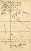
Western Kentucky State Teachers College Map |
Description |
Western Kentucky State Teachers College topographic map. Shows the location of the following buildings: Agricultural Pavilion (WKU) Cedar House (WKU) Cherry Hall (WKU) Cherryton (WKU) College High (WKU) Colonnade (WKU) Craig Alumni House (WKU) Gordon Wilson Hall (WKU) Health & Physical Education Building (WKU) Heating Plant (WKU) Home Economics Building (WKU) Industrial Education Building (WKU) Kentucky Building (WKU) Music Hall (WKU) Ogden Hall (WKU) Potter Hall (WKU) Red Barn (WKU) Rural Training School (WKU) Schneider Hall (WKU) Snell Hall (WKU) Stadium (WKU) Van Meter Hall (WKU) |
Collection |
WKU Archives |
Object Name |
Map |
Year Range From |
1937 |
Year Range To |
1938 |
Other Number |
D7242 |
Subjects |
Maps Dormitories Residential facilities Farms Topographic maps |
Search Terms |
Housing & Residence Life (WKU) Western Kentucky University Cherryton (WKU) Agricultural Pavilion (WKU) |
Catalog Number |
UA3.2.1.17 |
Dates of Creation |
ca. 1937 |
Caption |
D7242 |
Extent |
1 map |
Medium |
paper |
Area / Region |
Western Kentucky University |
Publisher |
Western Kentucky University |
Publication Place |
Bowling Green, KY |
Publication Date |
ca. 1937 |
Map Language |
English |
Scale |
2"=1000 yds, Contour int. |
Size |
8 x 13 |
Number of Sheets |
1 |
Number of Images |
1 |
Parent ID |
UA3.2.1 |
Level of Description |
Item |
Disciplines |
History Geography Urban, Community and Regional Planning Geographic Information Sciences |