

Archive Record
Images
Metadata
Title |
Southern Normal School Plan |
Creator |
Sanborn Map Company |
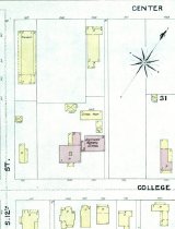
Description |
Layout of the Southern Normal School from Bowling Green Sanborn map bounded by 11th, 12th, Center and College Streets. Original map is available in the Kentucky Library. |
Collection |
WKU Archives |
Object Name |
Map |
Date |
1891 |
Year Range From |
1891 |
Year Range To |
1891 |
Other Number |
D4592 |
Subjects |
Maps |
Search Terms |
Southern Normal School (Bowling Green, KY) |
Catalog Number |
UA1A.14 |
Dates of Creation |
1891 |
Caption |
D4592 |
Extent |
1 map |
Medium |
paper |
Area / Region |
Southern Normal School |
Publisher |
Sanborn Map Company |
Publication Date |
1891 |
Map Language |
English |
Number of Sheets |
1 |
Number of Images |
1 |
Parent ID |
UA1A |
Level of Description |
Item |
Disciplines |
Higher Education Administration Geography Urban Studies Urban Studies and Planning Urban, Community and Regional Planning Architectural Engineering Architecture Construction Engineering |