Creator Record
Metadata
Name |
Sanborn Map Company |
Related Records
-
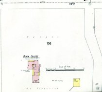
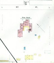
Ogden College Plan - Sanborn Map Company
Layout of Ogden College from Bowling Green Sanborn map, sheet 28. Original map is available in Kentucky Library.
Record Type: Archive
-
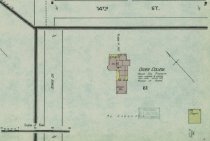
Ogden College Plan - Sanborn Map Company
Layout of Ogden College from Bowling Green Sanborn map sheet 5. Original map is available in Kentucky Library.
Record Type: Archive
-
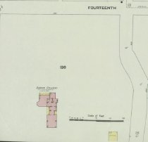
Ogden College Plan - Sanborn Map Company
Layout of Ogden College from Bowling Green Sanborn map at the corner of 14th Street and the Nashville Pike. Original map is available in the Kentucky Library.
Record Type: Archive
-
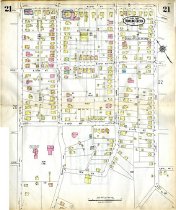
Potter College Plan - Sanborn Map Company
Page 21 of the Bowling Green, Kentucky Sanborn atlas showing Western Kentucky University. Original is available in the Kentucky Library.
Record Type: Archive
-
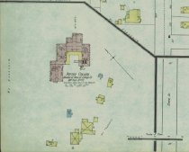
Potter College Plan - Sanborn Map Company
Layout of Potter College from Bowling Green Sanborn map along 15th Street. Original map is available in the Kentucky Library.
Record Type: Archive
-
Potter College Plan - Sanborn Map Company
Layout of Potter College from Bowling Green Sanborn map sheet 5. Original map is available in Kentucky Library.
Record Type: Archive
-
Potter College Plan - Sanborn Map Company
Layout of Potter College from Bowling Green Sanborn map. Original map is available in Kentucky Library.
Record Type: Archive

-
Sanborn Maps - Sanborn Map Company
Ogden College 1895 D67 Ogden College 1901 D4589 Ogden College 1909 D66 Potter College for Young Ladies 1895 D70 Potter College for Young Ladies 1901 D4590 Potter College for Young Ladies 1909 D65 Potter College for Young Ladies 1925 D4588 Southern Normal School 1895 D68
Record Type: Container

-
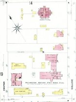
Southern Normal Plan - Sanborn Map Company
Layout of Southern Normal School & Bowling Green Business College from the Bowling Green Sanborn map sheet 6. Original map is available in Kentucky Library.
Record Type: Archive
-
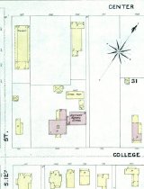
Southern Normal School Plan - Sanborn Map Company
Layout of the Southern Normal School from Bowling Green Sanborn map bounded by 11th, 12th, Center and College Streets. Original map is available in the Kentucky Library.
Record Type: Archive
-
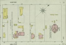
Western Kentucky University Plan - Sanborn Map Company
Layout of Western Kentucky University from Bowling Green Sanborn map bounded by 11th, 12th, Center and College Streets. Original map is available in the Kentucky Library.
Record Type: Archive
-
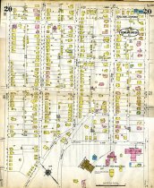
Western Kentucky University Plan - Sanborn Map Company
Page 20 of the Bowling Green, Kentucky Sanborn atlas showing Western Kentucky University. Original is available in the Kentucky Library.
Record Type: Archive